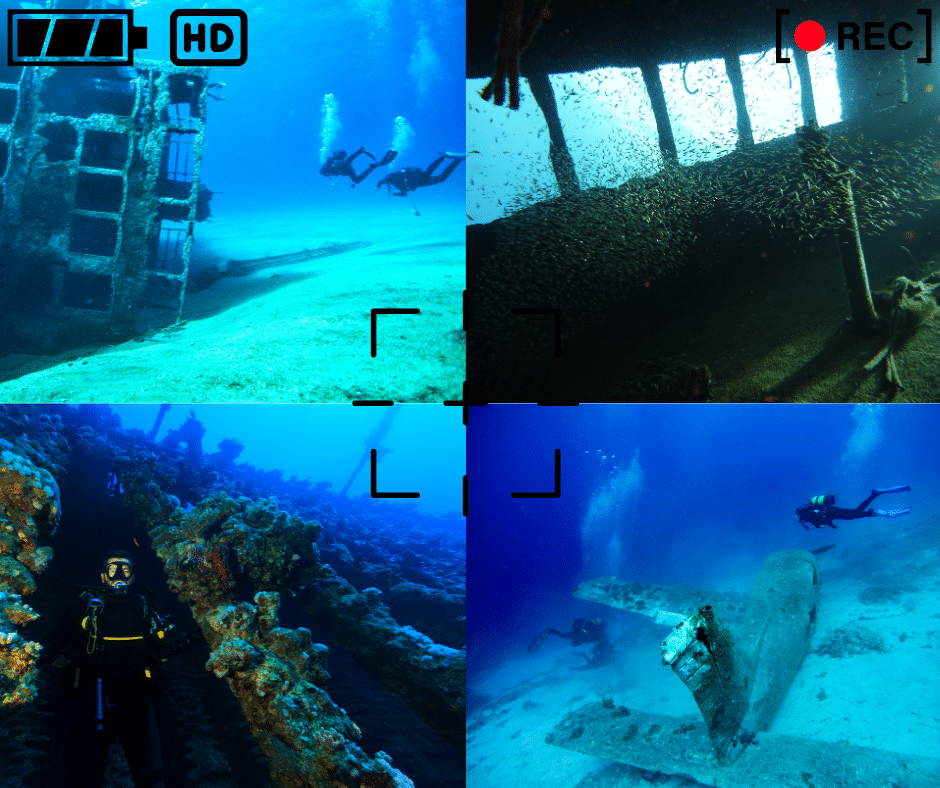
Shipwrecks are more than just rusty metal and decaying wood; they’re captivating time capsules, each with a unique story to tell. Often teeming with vibrant marine life, they offer incredible opportunities for underwater photography. Imagine capturing the ghostly silhouette of a schooner against a dramatic sunbeam, or the delicate detail of a centuries-old artifact encrusted with colorful sponges. At Double Action Dive Charters, we’re passionate about sharing these underwater museums with divers and photographers alike. To help you make the most of your wreck diving photography adventures, here are 11 essential tips:
Prioritize Safety (Above All Else)
This is the golden rule of wreck diving photography: your safety is paramount. No photo is worth risking your life or the well-being of your buddy.
- Always be aware of your buoyancy, depth limits, air consumption, and the potential hazards of the wreck environment.
- Remember that wrecks can present unique challenges, such as entanglement in debris, silt-outs that reduce visibility to zero, and unstable structures.
- If you’re not comfortable with the conditions or the dive plan, don’t hesitate to call off the dive.
Master Buoyancy Control
Excellent buoyancy control is not just good diving practice; it’s essential for wreck photography.
- Being neutrally buoyant allows you to hover effortlessly, maintain a stable position, and avoid kicking up silt or damaging the wreck.
- Practice your buoyancy skills in a pool or controlled environment before attempting to photograph wrecks.
- Use your breathing to make fine adjustments and minimize your fin movements.
Gear Up Appropriately
Choosing the right gear can significantly enhance your wreck photography.
- Wide-angle lenses are ideal for capturing the overall scene and the grandeur of the wreck.
- Strobes or video lights are crucial for illuminating the wreck and bringing out its true colors, especially in deeper or darker areas.
- Ensure your underwater camera housing is rated for the maximum depth of your dive and that it’s in good working order.
Plan Your Dive (and Your Shots)
Before you even enter the water, do your research. Learn about the history of the wreck, its layout, and any specific features you want to photograph.
- Identify potential compositions or shots you want to capture. This could include the bow, the stern, a specific artifact, or the marine life that has colonized the wreck.
- Planning your dive time and air consumption is crucial, as you’ll likely want to spend extra time at certain spots to get the perfect shot.
Get Close (But Not Too Close)
Water absorbs light and reduces visibility, so getting closer to your subject is key to capturing sharp and colorful images.
- Minimize the amount of water column between your camera and the wreck to improve clarity and color saturation.
- However, always maintain a safe distance and avoid touching or disturbing the wreck in any way. These sites are fragile and should be treated with respect.
Shoot from Different Angles
Don’t just settle for the obvious shots. Experiment with different angles and perspectives to create more dynamic and engaging images.
- Try shooting wide-angle shots to capture the entire wreck in its environment, then move in for close-ups of specific details.
- Shoot upward angles to emphasize the height of the wreck and the play of light on the surface.
- Shoot downward angles to reveal the wreck’s layout and its relationship to the seabed.
- Remember the rule of thirds for more balanced and visually appealing compositions.
Harness Natural Light (When Possible)
Natural light can be incredibly beautiful, especially in shallower wrecks where sunlight penetrates the water.
- Pay attention to the time of day and the angle of the sun to capture the best lighting conditions.
- Overcast days can diffuse the light and create a soft, even illumination.
Master Lighting Techniques
Artificial light from strobes or video lights is essential for bringing out color and detail in deeper or darker wrecks.
- Learn how to position your lights to avoid backscatter (particles in the water reflecting light back into the camera).
- Experiment with different lighting techniques to create dramatic effects and highlight specific features.
Capture the Story
Think beyond just taking pretty pictures. Try to capture the story of the wreck and its history.
- Focus on details like the ship’s wheel, the cargo, or the personal belongings left behind.
- Show the interplay of light and shadow to create a sense of mystery and intrigue.
- Capture the marine life that has made the wreck its home, highlighting the contrast between the man-made structure and the natural world.
Be Patient and Persistent
Underwater photography can be challenging. Visibility can change rapidly, and marine life may not always cooperate.
- Be patient, persistent, and willing to experiment.
- Don’t be discouraged if your first few shots aren’t perfect. Keep practicing and learning.
Practice, Practice, Practice
The best way to improve your underwater photography skills is to practice regularly.
- Start by practicing in a pool or controlled environment to get comfortable with your camera and lighting.
- The more you practice, the more confident and skilled you’ll become.
Frame the Past
Photographing shipwrecks is a rewarding way to combine your passion for diving with your creativity. By following these tips, you can capture stunning images that not only document these incredible sites but also tell their stories and inspire others to appreciate our underwater heritage. Double Action Dive Charters provides access to some of the most fascinating shipwrecks in the Great Lakes, offering you the opportunity to create your own unforgettable underwater photographic journey.